UK Map app for iPhone and iPad
4.0 (
8720 ratings )
Travel
Navigation
Developer:
Mappendix Limited
6.99 USD
Current version:
4.6, last update: 1 year ago
First release : 13 Apr 2010
App size: 285.8 Mb
* Unlimited free map downloads based on Ordnance Survey® OpenData, at 1:25,000 and 1:10,000 scales, and now also paid map downloads at 1:50,000, 1:25,000 and 1:10,000 scales, just like the paper maps. * 3D mode ideal for mountains. * Maps downloaded and saved for off-line use. * Mark waypoints, plan routes and record tracks. * Import and export GPX files. * Plot graphs of altitude and speed. * View your photos on the map. * Off-line place, street name and postcode search.
After installing the app, please touch the ? button to view instructions including how to download detailed maps.
Northern Ireland is not included. The Isle of Man is included only at 1:250,000 (free) and 1:50,000 (paid). The Channel Islands are not included.
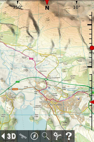
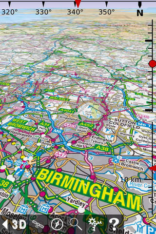
Since 2010, Britains national mapping agency Ordnance Survey has released a large amount of free map data. UK Map makes much of that data available in a single app. It includes 1:1M MiniScale® and 1:250k road maps, which are built into the app, and 1:25k district maps and 1:10k street maps for the entire country which you can download in 5km by 5km tiles. As the free O.S. data does not include footpaths, this app superimposes footpaths derived from volunteer-collected data from OpenStreetMap.org. These downloads are free of charge.
In addition to the free maps, you can also purchase and download 1:50,000 and 1:25,000 maps that are just like the Ordnance Survey paper maps. You can also purchase 1:10,000 maps for selected urban areas which show more detail than the free 1:10,000 maps.
Once youve downloaded the detailed maps that you need, an internet connection is not required.
The app can load GPX files (for example, from websites, other apps and from nearby devices via AirDrop) and display waypoints, tracks and routes. You can also mark waypoints, plan routes and record tracks within the app, and export them.
You can view graphs of altitude or speed along recorded tracks and routes.
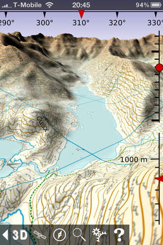
The app has a 3D mode that lets you view the terrain from any viewpoint, useful for visualising hills and mountains.
The app also includes a searchable gazetteer containing over 250,000 place names, 850,000 street names and 1.6 million post codes. All of this data is built in to the app, so this search also works when there is no network connection.
The app also supports the compass and GPS - on those devices that have them - to display your position, orientation and altitude.
Paid maps are licensed for personal and non-commercial use only.
Contains Ordnance Survey data © Crown copyright and database rights 2011 - 2021. Please visit the website for more information - https://ukmapapp.com/
Pros and cons of UK Map app for iPhone and iPad
UK Map app good for
This app help me a lot in my trip in Great Britan.
The detailed maps are fast to download (considering their size), and very very detailed.
And its much cheaper than buying many detailed maps of several regions.
Tips : while downloading detailed maps, its possible to resize the area and its possible to download several maps at a time !
Cette appli ma beaucoup aidé dans mon voyage en Grande-Bretagne.
Les cartes détaillées se téléchargent assez rapidement (si on considère la taille des fichiers) et sont très très détaillées.
Et au final, cela revient beaucoup moins cher que dacheter plusieurs cartes papier des différentes régions.
Astuces : quand vous sélectionnez une zone à télécharger, il est possible de choisir la taille de la zone en glissant le doigt. Il est également possible de télécharger plusieurs cartes détaillées en même temps.
I am preparing for my third walking visit to the UK (2013). Last year, UK Maps was a great help in planning my walks into Bodmin Moor and Dartmoor. This year, Ill be finding my way to several fishing streams in Scotland. Once again, this app has been an invaluable assistant for planning (and dreaming). I remember the weight and bulk of the Ordnance Survey maps I had to pack on my trip to Wales in 96, before the days of tablets and smartphones.... All these great maps stored in just one of many travel apps on my iPad which will be tucked into my backpack. It doesnt get any better than this!
There arent many apps for my iPad in the UK on the US store!! This will keep me busy until the end of may!!! Thank you!!
With the fixed version of the ap released today, all I can say is that UK Map is without equal and I wish I could give it 6 stars! The program is rock solid, the three levels of map detail are spot on and the new shaded topography and compass options make for a very appealing map experience. I only wish I had something like this for the US! It doesnt do routing - it does maps and it does them very well. The developer is extremely responsive and concerned. I highly recommend this program.
Great job by the developer! The only feature I could think to ask for would be a bookmarking function...
I like the U.S. but travel to the U.K. from time to time and have always liked the maps there. Navigation in England is much more a challenge than in the midwest U.S. Anyway, this is one of the first apps I bought on my iPad 3G and it has been excellent! There were some tech issues leading up to the UK iPad release but the developer was very responsive and got them fixed.
What I adore about this app is that there is no delay while maps download. The built-in Maps on the iPad is really good, but it does rely on an active data link for the images. UK Maps has them all on the local machine, and you can download and store additional street-level detail for selected areas. I am working out a five week trip for my daughter this summer and this mapping is very useful for that.
I would also note that last year I was over and had a Garmin GPS unit with me. This worked very well in getting me right to my next destination but at the cost of losing perspective about what was around me as I went, as I hadnt pored over maps picking the routes ahead of time. This UK Maps app would restore that perspective, its a pity the iPad wasnt out last year!
Although not by this developer, the Mini A-Z Map of London is also a good implementation of a machine-resident map. Like the UK Maps, it will show you your position using the 3Gs GPS when it can see the satellites.
Some bad moments
this app looked very good at first, and then when i zoomed in i could not zoom back out. i exited the program and when i went back in it was still zoomed in..?
This huge app, takes up a lot of memory and requires a long time to download detailed maps of each area you need. Worse, even after you have done that, the maps you have loaded are of no use if you arent in a wifi area. Total waste of money. If there were a rating lower than one star, I would have used it.
Usually UK Map iOS app used & searched for
os maps,
maps 3d gps,
mappendix limited,
and other. So, download free UK Map .ipa to run this nice iOS application on iPhone and iPad.